Digital mapping isn't just about A to B. It can raise awareness on gender, manage disasters & show government corruption

It’s something that urbanites use these days without thinking - the Google Map or CityMapper on their smart phone that calculates their optimum route though a busy, balancing life. But that’s us relying on the big Silicon Valley data banks, their GPS satellites, and their commitment to serving us as conveniently as possible.
What if we took a more active, creative, and ethical commitment to the digital maps in our lives? What patterns of power, resource, opportunity and danger should we be able to see clearly, in the geographies and real spaces of our lives? And how can we do our bit to fill those maps?
This fascinating article in Undark reveals a new civic practice. In their words, it’s where “individual volunteers and organizations contribute to OpenStreetMap by charting underserved regions through publicly available satellite imagery, conducting on-site surveys, and raising awareness of issues like gender discrimination, disaster management, and government corruption”.
What’s OpenStreetMap? It’s an open-source digital map of the world, which people can use, overlay and amend as they wish (much less controlling than Google and Apple). The UnDark article reports on several endeavours that use it to help them map a complex area or territory they are trying to assist or remediate.
Geochicas In Mexico
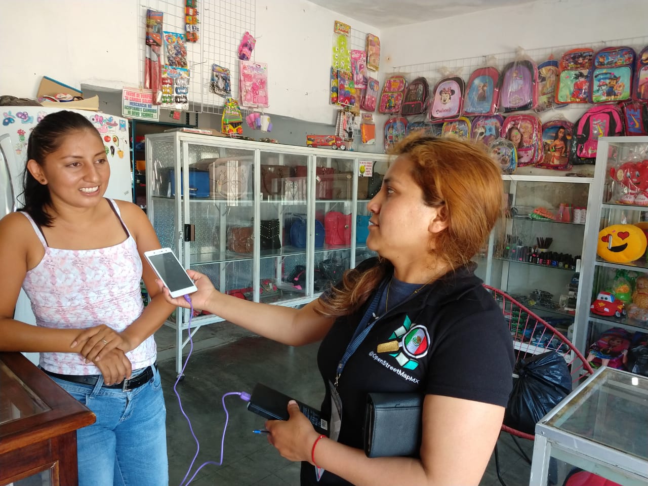
GeoChicas in action (link to article)
“In Feb 16, 2018, a 7.2 magnitude earthquake rocked the state of Oaxaca in Mexico, the third in a series of earthquakes to hit the country in less than a year. To provide shelter and offer aid to the people whose homes were destroyed, the Mexican federal government introduced temporary public shelters across the affected regions. But local communities in Mexico are understandably wary of government interventions, and women in disaster relief shelters are especially vulnerable to abuse and harassment.
“Later that year, an all-female team of volunteers known as Geochicas received a micro-grant to use OpenStreetMap, a free and open-source map of the world, to investigate the situation. The need for such work is vast. “Each year, disasters around the world kill nearly 100,000 and affect or displace 200 million people,” said Jorieke Vyncke, coordinator for the Missing Maps Project at Doctors Without Borders, an internet-based initiative that seeks to provide precise geodata for disaster-prone parts of the developing world.
“As part of their investigation, the Geochicas team toured 18 municipalities across Oaxaca, interviewing members of the local community and collecting information on the roads, houses, and public buildings through digital mapping technology.
“They found that residents seeking government help were often faced with issues like political favoritism and corruption, and so locals leaned on strong community ties to create their own temporary private shelters. Through mapping and interviews, Geochicas was able to show where women in these shelters felt safe from violence”.
There’s a fascinating passage on how they do their mapping:
Geochicas carries out most of their fieldwork with simple tools, according to González: a smartphone with GPS and a camera. The mapping consists of three steps.
First the team makes a map using publicly available satellite imagery from government and other open access sources.
Next, they go on site to develop a visual map of the area by taking pictures and using GPS with photo-mapping platforms like OpenStreetCam and Mapillary.
In the final step, the team scouts the area to determine any disparities between the satellite imagery and the reality on the ground, labeling buildings as business, residential, or institutional and plotting that data onto charts.
Mapping Saves Lives: Medecins Sans Frontiers
The UnDark piece also mentions how Medicines Sans Frontiers uses digital mapping in its work. The video below is concise: being able to put precise information about communities affected by the Ebola crisis in Sierra Leone, 2015, onto clearly readable and updatable digital maps, literally saved lives.
AI sees what needs to be made resilient
And to conclude, here’s a project that seeks to fuse together the community usage of OpenStreetMap with the superpowered computation of a Google Maps - sending camera-cars out to scan shanty towns and settlements, identifying quickly (and automatedly) which houses are most at need of reinforcement and resilient investment in any area. Funded by the World Bank, here’s a small insight from this Medium piece on how they’re doing it:
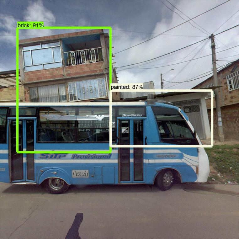
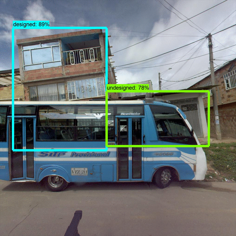
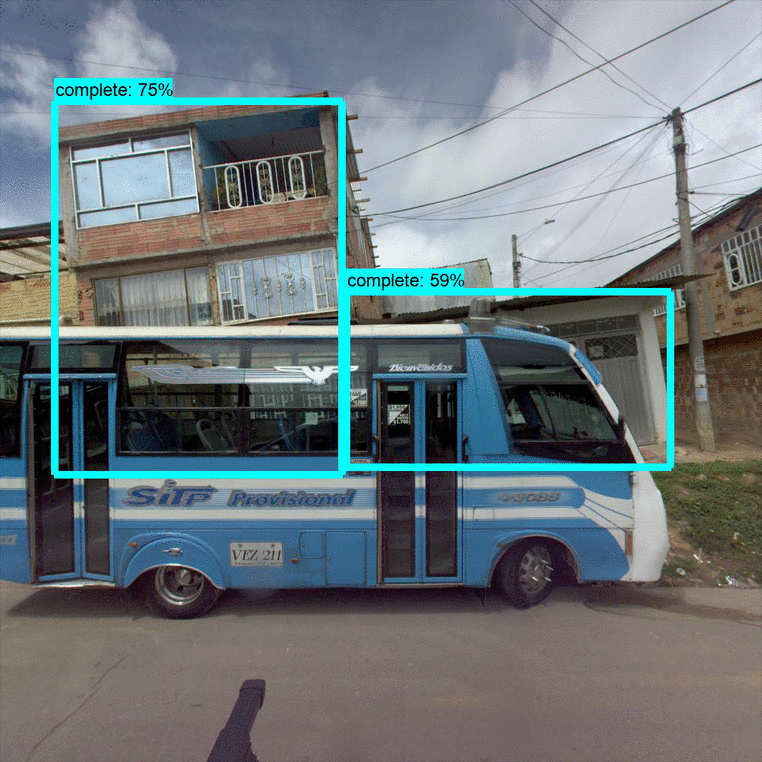
Retrofitting vulnerable buildings starts with finding them. Our automated “Housing Passport” tool creates a profile for each home using street view images analyzed by machine-learning models. We trained these machine-learning models… to detect three building characteristics: whether construction is complete or not, building material (e.g., concrete, brick, painted, etc.), and if the building was designed by an architect.
Our Data Team manually outlined these building properties in thousands of images. By showing example after example to our machine learning algorithm, the model learned to recognize these properties and draw its own bounding boxes [See below]: